- 1 reply
- 5,400 views
- Add Reply
- 4 replies
- 2,652 views
- Add Reply
- 0 replies
- 1,364 views
- Add Reply
- 0 replies
- 779 views
- Add Reply
- 1 reply
- 2,186 views
- Add Reply
asking question about geopands

By zolfa,
hello
how can i solve the problem of geopandas installation ?
i can not install geopandas in anaconda
would possible to help me ?
Terrain Modification with road networks

By Birdfree,
Hello, I am looking for a solution to merge elevation models with a road network. Basis is a elevation model and shape data of roads. Now I want to merge the roads with the elevation model to get flat roads in the elevation model. Do you know of any software that can do this? I have been searching for a while, but have not found a solution yet. So far I've been using Photoshop's blur to even out the color values a bit and at least get a decent result for large scales. But, the streets are sloped
NTIA's interactive broadband map highlights the digital divide

By Lurker,
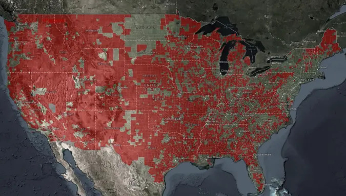
The quality and cost of broadband remain issues for households across the US, and the Biden administration wants to draw attention to that unfortunate reality. The National Telecommunications and Information Administration (NTIA) has published what it says is the first interactive public map detailing the "digital divide" in broadband access. You'll not only see areas where broadband speeds fall below official targets (25Mbps down and 3Mbps up), but correlate that with high-poverty areas. You ca
Managing earthquakes triggered by oil production: Scientists demonstrate safer wastewater disposal method
By Lurker,
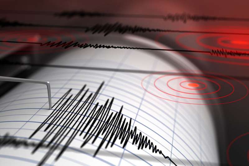
When humans pump large volumes of fluid into the ground, they can set off potentially damaging earthquakes, depending on the underlying geology. This has been the case in certain oil- and gas-producing regions, where wastewater, often mixed with oil, is disposed of by injecting it back into the ground—a process that has triggered sizable seismic events in recent years.
Now MIT researchers, working with an interdisciplinary team of scientists from industry and academia, have developed a meth
Landsat 7 End of Life Plans
By Lurker,

On February 7, 2017, the twentieth and final inclination (Delta-I) maneuver of Landsat 7 took place. (Delta-I maneuvers keep the spacecraft in the correct orbital position to ensure it maintains its 10:00 am ± 15 minutes mean local time (MLT) equatorial crossing.) Landsat 7 reached its peak outermost inclination boundary of 10:14:58 MLT on August 11, 2017.
Landsat 7 is now drifting in its inclination and will fall back to 09:15 am MLT by July 2021. The chart below illustrates the inclinati
-
Forum Statistics
8.7k
Total Topics43.2k
Total Posts
-
Latest Posts
-

By Robertobera · Posted
Сочные домашние котлеты — наверняка одно из любимых блюд каждого украинца. Они пропитаны любовью и заботой. Ниже мы расскажем, что учесть во время приготовления биточков [url=https://olesinrecept.cx.ua/]https://olesinrecept.cx.ua/[/url] -
 Hello folks! I am trying to use the Lyzenga Algorithm for estimating the depth of water in shallower areas, probably depths under 8-10 meters of lakes. First of all, how accurate is this algorithm in practice? Secondly, lets say i have the band values. can someone explain me how to retrieve those depths? I am following the "Lyzenga Algorithm for Shallow Water Mapping Using Multispectral Sentinel-2 Imageries in Gili Noko Waters" paper, but there are 3 steps of getting NDWIs, NDCIs and after filtering the Sun Glint Correction, then it finally comes to the depth calculating. it end ups in a formula of following: 𝑧 = 28.32 ∗ 𝑋1 − 36.25 ∗ 𝑋2 + 9.42 ∗ 𝑋3 + 16.35 x1 , x2, x3 are RGB values respectively. What do you guys think? can i just apply this formula ? if not, what is the purpose of all the previous steps, and will they change the rgb values anyways?
 -
Hello folks! I am trying to use the Lyzenga Algorithm for estimating the depth of water in shallower areas, probably depths under 8-10 meters of lakes. First of all, how accurate is this algorithm in practice? Secondly, lets say i have the band values. can someone explain me how to retrieve those depths? I am following the "Lyzenga Algorithm for Shallow Water Mapping Using Multispectral Sentinel-2 Imageries in Gili Noko Waters" paper, but there are 3 steps of getting NDWIs, NDCIs and after filtering the Sun Glint Correction, then it finally comes to the depth calculating. it end ups in a formula of following: 𝑧 = 28.32 ∗ 𝑋1 − 36.25 ∗ 𝑋2 + 9.42 ∗ 𝑋3 + 16.35 x1 , x2, x3 are RGB values respectively. What do you guys think? can i just apply this formula ? if not, what is the purpose of all the previous steps, and will they change the rgb values anyways?
-
 Интересно: [url=https://autoplenka.com/product-tag/sine-zelenyj/]antiskol[/url] или [url=https://autoplenka.com]пленка на лобовое стекло автомобиля[/url] Может быть полезным: https://autoplenka.com/product/nabor-iz-3-myagkih-vygonok-trapecziya/ или [url=https://autoplenka.com]пленка для тонировки стекол автомобиля[/url] Ещё можно узнать: [url=http://yourdesires.ru/home-and-family/cookery/232-kak-prigotovit-shpikachki-v-domashnih-usloviyah.html]шпикачки дома[/url]
-
-
Latest Topics
-
-
Recent Achievements
-


