- 0 replies
- 706 views
- Add Reply
- 0 replies
- 1,049 views
- Add Reply
- 0 replies
- 1,824 views
- Add Reply
- 0 replies
- 1,868 views
- Add Reply
HISTARFM - How to Work with Gap-Filled Imagery

By Lurker,
Although there is an extensive array of optical remote sensing sensors from a variety of satellites providing long time data records, their data are incapable of retrieving reliable land surface information when clouds, aerosols, shadows, and strong angular effects are present in the scenes. The mitigation of noise and gap filling of satellite data are preliminary and almost mandatory tasks for any remote sensing application aimed at effectively analyzing the earth's surface continuously through
Happy Belated GIS Day

Copernicus Emergency Management Service releases GloFAS v4.0 hydrological reanalysis
By Lurker,
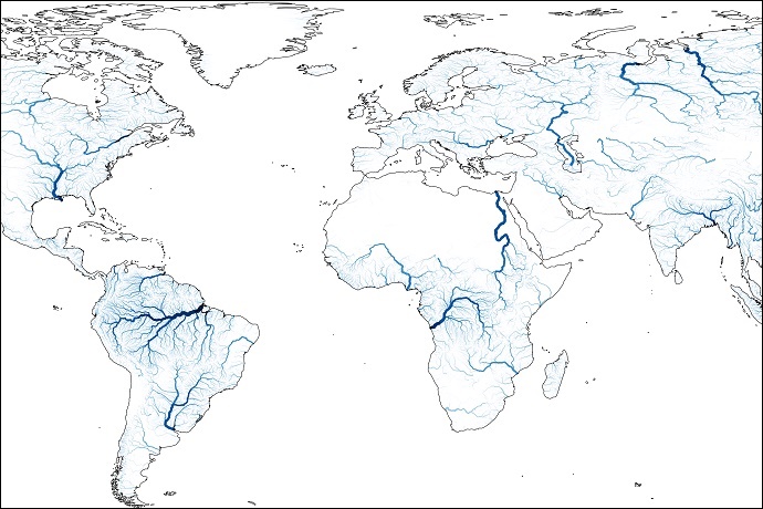
A new, substantially upgraded hydrological reanalysis dataset of the Global Flood Awareness System (GloFAS) from 1980 to July 2022 has been produced by the Joint Research Centre (JRC) of the European Commission in collaboration with ECMWF and released as part of the Copernicus Emergency Management Service (CEMS). It puts river discharge and flood events during that period at the fingertips of users.
The GloFAS v4.0 reanalysis includes daily maps of discharge over the globe at a resolution o
The New RIEGL VZ-600i
By Lurker,

RIEGL’s new era of Terrestrial Laser Scanners: the VZ-600i stands out with extreme versatility, high productivity, radical performance, and game changing mobility features.
With 3D position accuracy of 3 mm and less than 30 sec scan time for high-resolution scans with 6 mm point spacing at 10 m, this enables more than 60 scan positions/hour with real-time registration. Featuring a weight less than 6 kg (13 lbs), 2.2 MHZ PRR, three internal cameras & GNSS integrated, and prepared fo
UP42 Launches ArcGIS Pro Add-in
By Lurker,

The UP42 ArcGIS Pro Add-in is a UI extension that lets ArcGIS Pro users quickly access UP42 storage and projects. The add-in will enable ArcGIS Pro users to seamlessly visualize and analyze their downloaded imagery from UP42 without leaving the Esri ecosystem.
Technical Information
The UP42 add-in for ArcGIS Pro offers users an easy, intuitive way to simplify and streamline their data access and visualization workflows. After ordering geospatial imagery from the leading dat
-
Forum Statistics
8.7k
Total Topics43.2k
Total Posts
-
Latest Posts
-

By Robertobera · Posted
Сочные домашние котлеты — наверняка одно из любимых блюд каждого украинца. Они пропитаны любовью и заботой. Ниже мы расскажем, что учесть во время приготовления биточков [url=https://olesinrecept.cx.ua/]https://olesinrecept.cx.ua/[/url] -
 Hello folks! I am trying to use the Lyzenga Algorithm for estimating the depth of water in shallower areas, probably depths under 8-10 meters of lakes. First of all, how accurate is this algorithm in practice? Secondly, lets say i have the band values. can someone explain me how to retrieve those depths? I am following the "Lyzenga Algorithm for Shallow Water Mapping Using Multispectral Sentinel-2 Imageries in Gili Noko Waters" paper, but there are 3 steps of getting NDWIs, NDCIs and after filtering the Sun Glint Correction, then it finally comes to the depth calculating. it end ups in a formula of following: 𝑧 = 28.32 ∗ 𝑋1 − 36.25 ∗ 𝑋2 + 9.42 ∗ 𝑋3 + 16.35 x1 , x2, x3 are RGB values respectively. What do you guys think? can i just apply this formula ? if not, what is the purpose of all the previous steps, and will they change the rgb values anyways?
 -
Hello folks! I am trying to use the Lyzenga Algorithm for estimating the depth of water in shallower areas, probably depths under 8-10 meters of lakes. First of all, how accurate is this algorithm in practice? Secondly, lets say i have the band values. can someone explain me how to retrieve those depths? I am following the "Lyzenga Algorithm for Shallow Water Mapping Using Multispectral Sentinel-2 Imageries in Gili Noko Waters" paper, but there are 3 steps of getting NDWIs, NDCIs and after filtering the Sun Glint Correction, then it finally comes to the depth calculating. it end ups in a formula of following: 𝑧 = 28.32 ∗ 𝑋1 − 36.25 ∗ 𝑋2 + 9.42 ∗ 𝑋3 + 16.35 x1 , x2, x3 are RGB values respectively. What do you guys think? can i just apply this formula ? if not, what is the purpose of all the previous steps, and will they change the rgb values anyways?
-
 Интересно: [url=https://autoplenka.com/product-tag/sine-zelenyj/]antiskol[/url] или [url=https://autoplenka.com]пленка на лобовое стекло автомобиля[/url] Может быть полезным: https://autoplenka.com/product/nabor-iz-3-myagkih-vygonok-trapecziya/ или [url=https://autoplenka.com]пленка для тонировки стекол автомобиля[/url] Ещё можно узнать: [url=http://yourdesires.ru/home-and-family/cookery/232-kak-prigotovit-shpikachki-v-domashnih-usloviyah.html]шпикачки дома[/url]
-
-
Latest Topics
-
-
Recent Achievements
-


